Mapping Yale, Part Two
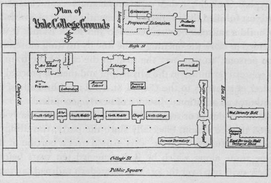
The beginnings of today’s Old Campus quadrangle are clear in this “Plan of Yale College Grounds,” ca. 1877, perhaps drawn by Benjamin Silliman, Jr. (Class of 1837; Professor of General and Applied Chemistry). New construction included Yale’s first stone building, the Library (1842–46; now Dwight Hall); Street Hall (1864) for the School of the Fine Arts; Alumni Hall (1851–53; site of Wright Hall); Battell Chapel (1874–76); and Farnam (1869–70) and Durfee (1871) Halls. But Yale had also begun to expand beyond that quadrangle. First to be built was the original Gymnasium (1859; site of Branford College), followed by a new home for the Divinity School on the far side of Elm Street (1869–70; site of Calhoun College) and the first Peabody Museum (1873–76; site of Saybrook College), though the extension proposed in this plan was never realized. The many dots on the plan represent rows of the giant elm trees for which New Haven was famous. Those not felled to make way for further expansion of the quadrangle were lost to Dutch Elm disease in the twentieth century.
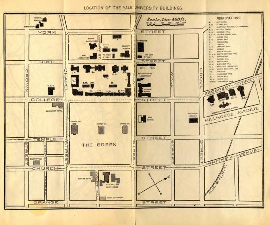
In 1900, this 2-panel foldout map of the campus was published in the Catalogue of Yale University, the predecessor to the Bulletin of Yale University series. Although the campus map was oriented with west at the top, a map of New Haven on its verso, with concentric circles marking the distance from Old Campus in half-miles, was positioned with north at the top. This regional map allowed the Yale athletic fields, Infirmary, Observatory, and Boathouse to be shown for the first time.
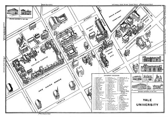
Bird’s-eye-view map, 1912–13, from the Bulletin of Yale series. Even this 3-panel foldout couldn’t accommodate the growing campus; buildings south of Chapel and north of Trumbull are relegated to insets. The map was drawn by Matthews-Northrup Works of Buffalo, New York, which was run by a member of the Class of 1877.
- Log in to post comments.